Block 3 Resources
| Site: | Dr. B.R. Ambedkar Open University Online Learning Portal |
| Course: | PHYSICAL GEOLOGY |
| Book: | Block 3 Resources |
| Printed by: | Guest user |
| Date: | Sunday, 19 July 2026, 7:43 PM |
Description
Block–3 focuses on the external geological processes that operate on the surface of the Earth. These processes are mainly driven by atmospheric factors such as temperature variations, rainfall, and gravity. Unlike internal (endogenic) processes that originate within the Earth, external (exogenic) processes continuously act on the surface and modify landforms over time.
This block is divided into three important units:
- Rock Weathering – This unit deals with the types and processes of weathering, including physical, chemical, and biological weathering. It also explains their significant role in the breakdown of rocks and the formation of soil.
- Rivers – This unit explains the role of running water as a powerful geological agent. It covers processes such as erosion, transportation, and deposition, along with the formation of river valleys and associated landforms.
- Groundwater – This unit focuses on the occurrence and movement of groundwater, its importance as a natural resource, and its role in forming underground features. It also highlights aspects of water resource management.
Overall, the study of these processes helps in understanding landscape evolution, soil formation, river systems, and the sustainable use of water resources.
1. UNIT-7 ROCK WEATHERING
Weathering is the process by which rocks are broken down into smaller fragments at or near the earth’s surface. It is an external geological process that operates under the influence of atmospheric agents. Weathering does not involve transportation of materials but only their disintegration and decomposition. It plays a vital role in soil formation and landscape development.
Objectives
After studying this unit, you should be able to:
Define weathering and its types
Explain physical, chemical, and biological weathering
Understand factors affecting weathering
Describe the importance of weathering
ROCK WEATHERING
Weathering is defined as a process of decay, disintegration and decomposition of rocks under the influence of certain physical and chemical agencies.
Weathering is a natural process of in-situ mechanical disintegration and/or chemical decomposition of the rocks of the crust of the Earth by certain physical and chemical agencies of the atmosphere.
The most important aspect of this process is that the weathered product remains lying over and above or near to the parent rock unless it is removed from there by some other agency of the nature.
a) Disintegration: It may be defined as the process of breaking up of rocks into small pieces by the mechanical agencies of physical agents.
b) Decomposition: It may be defined as the process of breaking up of mineral constituents to form new components by the chemical actions of the physical agents.
c) Denudation: It is a general term used when the surface of the earth is worn away by the chemical as well as mechanical actions of physical agents and the lower layers are exposed.
The process of weathering depends upon the following three factors:
- Nature of rocks
- Length of time
- Climate
Three types of weathering are commonly distinguished on the basis of type of agency involved in the process and nature of the end product. They are:
1) Physical or mechanical weathering
2) Chemical weathering
3) Biological weathering
I. PHYSICAL OR MECHANICAL WEATHERING
Physical or mechanical weathering is the process by which rocks break into smaller fragments without any change in their chemical composition. During mechanical weathering, the fragments produced still contain the same characteristics as the original rock. The breaking of rocks into smaller pieces exposes fresh surfaces to air and water. These fresh surfaces allow chemical reactions to occur more easily.
Therefore, mechanical weathering often supports and accelerates chemical weathering. In nature, physical and chemical weathering usually occurs together.
There are several important factors responsible for physical weathering.
The main factors include frost action, temperature changes, the mechanical effects of plants and animals, and gravity.
1. Frost Action (Wedge Work of Ice)
Frost action occurs when water enters cracks, joints, and bedding planes in rocks. When the temperature falls below freezing point, the water freezes and expands.The expansion of ice exerts strong pressure on the surrounding rock. This pressure gradually widens the cracks and weakens the rock. Repeated freezing and thawing eventually break the rock into fragments. This process is very common in cold and mountainous regions. During the daytime in mountain areas, rocks may become warm or hot due to sunlight. At night, the temperature may fall below the freezing point. Under such conditions, freeze–thaw action becomes very effective. The broken rock fragments produced by frost action move downward and accumulate at lower slopes.
2. Effects of Changing Temperatures
Temperature changes also play an important role in mechanical weathering. This process is common in desert and semi-arid regions. During the daytime, rocks are heated to very high temperatures by the sun. At night, the temperature drops sharply. Rocks are poor conductors of heat, so only the outer layers are affected. The outer layers expand when heated and contract when cooled. Repeated expansion and contraction cause cracks in the rock surface. Gradually the outer layers separate from the main rock body. These thin layers peel off in curved shells. This process is called Exfoliation. Exfoliation is common in massive rocks such as granite and basalt.
Spheroidal Weathering
Exfoliation often results in rounded rock masses. This process is called Spheroidal Weathering. The rounded rock masses formed are known as residual boulders. Weathering usually begins at the edges and corners of rocks. Sharp edges and corners wear away first. As weathering continues, the rocks develop rounded shapes. Because of this process, some hills gradually become dome-shaped. On convex slopes, the separated shells may appear overlapping like roof tiles. Good examples of such landforms are Inselbergs, which are isolated rocky hills. These are commonly found in Mozambique and other parts of Africa. Another famous example is Sugar Loaf Hill in Rio de Janeiro, Brazil.
3. Mechanical Work of Plants and Animals
Plants and animals also contribute to mechanical weathering. Roots of plants and trees grow into cracks and crevices of rocks. As the roots grow thicker, they exert pressure on the rock walls. This pressure widens the cracks and breaks the rocks apart. Burrowing animals also play an important role in weathering. Animals such as earthworms and rodents dig into the soil and rock. Their activity loosens the rock material. They bring partly weathered rock fragments to the surface. These fragments are then exposed to air, water, and further weathering. It is estimated that earthworms may bring more than 10 tons of soil particles per acre to the surface every year.
Role of Microorganisms
Plants such as lichens and fungi contribute to weathering. They extract certain minerals and elements from rocks. Water containing bacteria attacks rock minerals actively. Dead organisms in soil decompose due to the action of soil bacteria and fungi. This process produces a brown, jelly-like organic material called humus. Humus is an important organic component of soil. It can dissolve small quantities of minerals such as limonite.
4. Action of Gravity
Gravity also plays an important role in weathering. It helps in the removal of weathered rock materials. When weathered debris moves downward, fresh rock surfaces are exposed for further weathering. Gravity causes the slow downward movement of loose rock fragments. In steep mountain regions, rock fragments fall down from cliffs. These fragments accumulate at the base of the slopes. Such accumulations of broken rock fragments are called Talus. The slope of a talus deposit is usually about 25° to 30°.
Chemical weathering is the process by which rocks are decomposed through chemical reactions. These reactions change the internal structure and composition of minerals. During chemical weathering, the original rock transforms into new substances. These new substances remain stable under the existing environmental conditions. Water is the most important agent of chemical weathering. Water acts as a solvent and carrier of dissolved gases such as oxygen and carbon dioxide. It may also contain acids and organic substances from the soil. The rate of chemical weathering depends on several factors.
These factors include:
- Composition of the rock
- Temperature
- Concentration of chemical solutions
- Presence of bacteria
- Pressure conditions
Most minerals decompose during chemical weathering. However, some minerals such as quartz and muscovite are resistant to weathering. Minerals like calcite dissolve completely in water. Many silicate minerals break down into clay minerals. At the same time, soluble substances are carried away in solution.
2. CHEMICAL WEATHERING
The main processes of chemical weathering include:
1. Solution
2. Oxidation
3. Hydration
4. Carbonation
1. Solution
Solution occurs when minerals dissolve directly in water. Rainwater contains dissolved carbon dioxide from the atmosphere. This forms carbonic acid. Carbonic acid reacts with rocks and dissolves certain minerals. Limestone is particularly susceptible to solution weathering. In this reaction, calcium carbonate is converted into soluble calcium bicarbonate. Example:
CaCO₃ + H₂O + CO₂ → Ca(HCO₃)₂
This soluble compound can be carried away by water. In limestone regions, solution weathering forms grooves and furrows on rock surfaces. Such features are commonly found in the Pennines of England near Ingleborough. When limestone contains impurities such as clay and quartz, these materials remain behind. They accumulate and form residual soil deposits.
Examples include:
Terra Rossa soil in karst regions
Clay with flints in chalk landscapes
2. Oxidation
Oxidation occurs when oxygen reacts with minerals in rocks. Water containing dissolved oxygen attacks iron-bearing minerals. Iron changes from ferrous iron to ferric iron. This produces minerals such as hematite, limonite, and goethite. Oxidation causes colour changes in rocks. Rocks may change from green or black to red, yellow, or brown. Because of oxidation, many soils in warm humid regions appear red or yellow.
3. Hydration
Hydration occurs when water molecules combine chemically with minerals. This process forms new hydrous minerals. For example, feldspar minerals in granite are converted into clay minerals such as kaolin. The reaction also produces silica and other dissolved substances.
Other hydrous minerals formed by hydration include: Serpentine, Talc, Chlorite, Zeolite.
4. Carbonation
Carbonation occurs when carbon dioxide reacts with minerals in rocks. Carbon dioxide dissolves in water and forms carbonic acid. This weak acid reacts with minerals such as calcium, magnesium, sodium, and potassium oxides. These reactions produce carbonates or bicarbonates. Carbonated water can dissolve minerals more easily than pure water. Therefore, it is a very active agent of chemical weathering. Weathered rock surfaces often show rusty brown stains due to iron compounds.
Importance of Chemical Weathering
Chemical weathering contributes to the breakdown of rocks in several ways. It weakens the bond between mineral grains. It produces soluble compounds that are washed away by rainwater. This makes rocks porous and weak. Chemical weathering may also produce new minerals with larger volume. These expansion processes can cause the outer layers of rocks to peel away. This effect may contribute to exfoliation of rocks.
Influence of Climate on Weathering
Climate is one of the most important factors controlling the type and intensity of weathering. Temperature, rainfall, moisture, and vegetation determine whether mechanical or chemical weathering dominates. Different climatic regions show different weathering characteristics.
1. Equatorial Climate
Equatorial regions have high temperature and heavy rainfall throughout the year. Chemical weathering is very intense because heat and moisture accelerate chemical reactions. Dense vegetation also contributes organic acids that help in rock decomposition. Silicate minerals break down rapidly and silica is removed in solution. The typical product of weathering in this region is laterite, rich in iron and aluminum oxides.
2. Desert Climate
Desert regions are hot and dry with very little rainfall and vegetation. Mechanical weathering is dominant due to large daily temperature variations causing expansion and contraction of rocks. Salt crystallization also breaks rocks apart. Evaporation of groundwater may cement surface materials forming hardpan. A common feature of desert rocks is desert varnish, a dark coating of iron and manganese oxides.
3. Temperate Climate
Temperate regions experience moderate climate with seasonal variations. In winter, frost action causes mechanical weathering as water freezes and expands in rock cracks. In summer, chemical weathering becomes active due to moisture and moderate temperature. Thus, both mechanical and chemical weathering occur in these regions.
4. Arctic Climate
Arctic regions are extremely cold and snow-covered for most of the year. Meltwater repeatedly freezes and thaws in rock cracks, producing frost wedging. Mechanical weathering is dominant and produces sharp peaks and ridges. Large quantities of rock debris accumulate due to continuous disintegration.
3. BIOLOGICAL WEATHERING
Products of Weathering – Soils
Weathering of rocks produces soil, which is an important natural resource. When rock is weathered, it forms loose material called regolith above the bedrock. If the bedrock is exposed at the surface, it is called an outcrop.
Soil is a mixture of mineral particles, organic matter, water, and air. Soil formation depends on several factors such as parent rock material, climate, living organisms, land slope, and time.
Types of Soils
1. Residual Soil
Residual soils are formed directly from the weathering of underlying bedrock and remain in the same place. They gradually change downward into subsoil and then into bedrock.
2. Transported Soil
Transported soils are formed from weathered materials that have been moved from their original place by agents such as wind, water, glaciers, or gravity.
3. Major Soil Types
1. Lateritic Soil: Formed in hot and humid climates; rich in iron and aluminum oxides but poor in nutrients.
2. Black Soil (Chernozem / Black Cotton Soil): Derived from basalt; rich in minerals and suitable for cotton cultivation.
3. Podsol Soil: Developed in cold and moist climates under coniferous forests; generally acidic and less fertile.
4. Loamy Soil: Contains balanced amounts of sand and clay; very fertile and suitable for agriculture.
Mass Wasting
Mass wasting refers to the down slope movement of weathered rock materials under the influence of gravity. It is an important process in landscape development and occurs after weathering has weakened the rocks.
Gravity is the main force responsible for mass wasting, but other factors such as water also play an important role. When soil becomes saturated with water, its weight increases and the cohesion between particles decreases. This makes it easier for the material to slide or flow downhill.
Mass wasting includes various movements such as rock falls, landslides, and soil creep, which transport weathered materials from higher slopes to lower areas.
2. UNIT-8 RIVERS
Rivers are important geological agents that modify the earth’s surface through erosion, transportation, and deposition. Running water plays a dominant role in shaping landscapes. Rivers originate from rainfall, springs, or melting snow and flow towards oceans or lakes.
Objectives
After studying this unit, you should be able to:
Explain the geological work of rivers
Understand erosion, transportation, and deposition
Identify river landforms
Describe the role of rivers in landscape development
Precipitation and Runoff
Water enters the Earth’s surface mainly as rain, sleet, hail, and snow, which is called precipitation. Some of this water evaporates, some infiltrates into the ground as groundwater, and some flows over the land as runoff. About 22% of precipitation on land becomes runoff, which flows through streams and rivers. Running water is the most important agent of denudation because it erodes and shapes the land surface.
The catchment area is the region that receives rainfall and supplies water to a river system. The distribution of rainfall is controlled mainly by winds carrying water vapor, which later condenses and falls as precipitation.
Geological Work of Rivers
Rivers perform three major geological activities:
Erosion
Transportation
Deposition
1. Erosion
Erosion is the process by which rivers wear away rocks and soil from the land surface. It occurs mainly by three processes.
Hydraulic Action:
The force of moving water loosens and removes rock particles from the river bed and banks.
Abrasion (Corrasion):
Rock fragments such as sand, pebbles, and boulders carried by the river rub against the channel, causing mechanical wear of rocks.
Solution:
River water dissolves soluble minerals from rocks and carries them in dissolved form.
2. Transportation
The materials carried by a river are called its load. The load is transported in different ways:
Traction: Large particles slide or roll along the river bed.
Saltation: Sand-sized particles jump or bounce along the bed.
Suspension: Fine particles like silt and clay are carried in the water.
Solution: Soluble minerals are carried in dissolved form.
3. Deposition
Deposition occurs when the velocity of the river decreases, causing sediments to settle down. Deposited river sediments are called alluvium. Deposition commonly occurs during floods when rivers carry a large amount of sediment.
Important Geological Features of Rivers
Waterfalls
A waterfall is formed when a river flows over a steep cliff or resistant rock layer. The falling water erodes the base of the cliff, causing the waterfall to retreat upstream over time.
Oxbow Lake
Rivers flowing through broad valleys often form meanders (loop-like bends). When erosion cuts through the narrow neck of a meander, the loop becomes separated from the river and forms an oxbow lake.
Alluvial Fan
An alluvial fan is a fan-shaped deposit of sediments formed when a river flowing down a steep slope suddenly enters a flat plain. The sudden decrease in velocity causes sediments to accumulate.
Delta
A delta is formed when a river enters a sea or lake and deposits its sediments. The river divides into several smaller channels called distributaries and builds a triangular deposit resembling the Greek letter delta (Δ).
Drainage System
A drainage basin is the area drained by a river and its tributaries. The boundary separating two drainage basins is called a drainage divide.
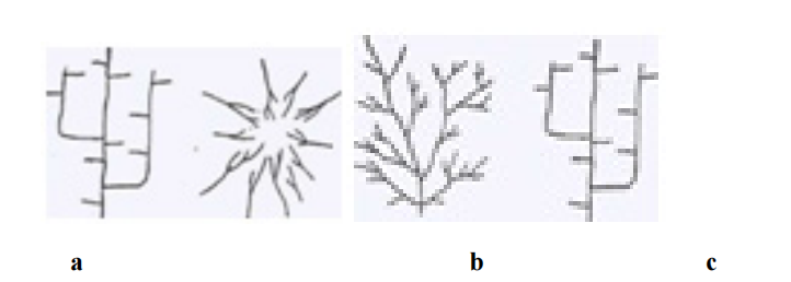
Types of Drainage Patterns
Dendritic Pattern: Tree-like branching pattern formed on uniform rocks.
Trellis Pattern: Formed where hard and soft rock layers alternate.
Radial Pattern: Streams flow outward from a central high point such as a volcano or dome.
Parallel Pattern: Streams flow in the same direction, following a steep, uniform slope.
Valley Development
Valley development is a geomorphological process in which running water gradually erodes land and forms valleys. Rainwater flowing over the land surface first moves as thin sheets, then forms small channels called rills. These rills combine to form gullies, which later join to form streams and rivers that cut deeper channels in the land.
Formation of Streams and Valleys
During heavy rainfall, surface water flows through gullies and gradually deepens them. With time, side gullies develop and grow into tributaries, collecting water from a large drainage area. The increased volume of water increases stream velocity and erosive power, which leads to further deepening of the valley.
Streams that flow only during rainy seasons are called intermittent streams. When a valley deepens enough to reach the groundwater table, the stream receives continuous water supply and becomes a permanent stream.

Graded Streams and Base Level
When a balance exists between erosion and deposition, the stream is called a graded stream. Such streams adjust their slope so that they can carry their load without excessive erosion or deposition.
The lowest level to which a river can erode its channel is called the base level of erosion. Usually, the sea level or the level of a lake acts as the base level for most rivers.
Valley Widening (Lateral Erosion)
In addition to deepening, valleys also widen due to lateral erosion. In some regions, deep valleys with steep walls are formed where vertical erosion dominates, such as in the Colorado River valley.
Valley widening occurs through several processes, including:
Creeping and slumping of valley sides
Rain wash
Activities of plants and animals
Glacial erosion
Undercutting by streams
Action of tributaries
Another important factor is meandering. When a river bends, the water flows faster along the outer bank, causing erosion and gradually widening the valley.
River Development (Cycle of Erosion)
River development refers to the gradual evolution of landscapes due to stream erosion. As rivers erode the land surface over time, the landscape passes through different stages collectively called the cycle of erosion.
1. Youthful Stage
The youthful stage begins after uplift of land, when rivers start eroding the surface. In this stage, stream gradients are steep and erosion is very rapid. Valleys are deep, narrow, and V-shaped, and the valley sides are steep.
Streams flow rapidly and often contain rapids and waterfalls. Tributaries are few, and the drainage system is not fully developed. A classic example of a youthful valley is the Grand Canyon formed by the Colorado River.
2. Mature Stage
In the mature stage, erosion continues and the landscape becomes highly dissected by numerous valleys and tributaries. The valleys become wider with gentler slopes, and the sharp features of the youthful stage gradually disappear.
Streams develop gentler gradients, and erosion becomes slower. Lakes and swamps are drained or filled, and waterfalls gradually disappear as the river approaches a graded condition.
3. Old Age Stage
In the old age stage, erosion reduces the land surface close to the base level. Valleys become very wide with gentle slopes, and the streams flow slowly with large meanders.
At this stage, rivers deposit more sediment than they erode. The landscape eventually becomes a nearly flat plain called a peneplain.
Monadnocks
Even in a peneplain, some isolated hills made of resistant rocks remain standing above the plain. These residual hills are called monadnocks, named after Mount Monadnock.
Types of Streams
Streams are classified into different types based on their origin, flow direction, and relationship with landforms and rock structures. The classification of streams helps in understanding the geological history and development of drainage systems.
1. Consequent Streams
Consequent streams are the first streams that develop on a newly uplifted land surface. Their direction of flow is mainly controlled by the original slope and natural irregularities of the land surface. These streams flow down the initial slope of the terrain and therefore directly follow the original topography.
As erosion continues, consequent streams may extend their length by headward erosion and widen their valleys. Tributaries may also develop as a result of the initial slope conditions. Consequent streams are commonly found in regions of massive or horizontally lying rocks and usually show a dendritic drainage pattern, which resembles the branches of a tree.
2. Subsequent Streams
Subsequent streams develop after the formation of consequent streams and are influenced mainly by the structure and resistance of rocks. These streams flow along zones of weak rocks or softer rock layers, where erosion occurs more easily.
Their course is not controlled by the original slope of the land, but rather by differences in rock hardness and structure. Subsequent streams often join the main consequent streams at nearly right angles, forming a trellis drainage pattern. This pattern commonly develops in areas with alternating hard and soft rock layers.
3. Obsequent Streams
Obsequent streams are tributaries of subsequent streams that flow in the opposite direction to the original consequent streams. These streams develop due to erosion in regions where the rock layers are tilted or inclined.
Obsequent streams are commonly found in areas with cuesta landforms, where erosion gradually wears down the land surface and forms new stream courses flowing opposite to the initial slope direction.
4. Antecedent Streams
Antecedent streams are rivers that existed before the uplift of mountains or other geological structures. When the land was uplifted due to folding or faulting, the river maintained its original course by continuously eroding its channel.
As a result, the river cuts deep valleys or gorges across the rising structures. The term "antecedent" means that the stream is older than the uplifted landform.
5. Superimposed Streams
A superimposed stream is one that develops on a surface of younger rock layers and later cuts down into older underlying rocks. Initially, the stream flows according to the surface topography of the overlying rocks.
As erosion removes the upper layers, the stream continues to maintain its original course even when it reaches different rock structures below. Therefore, the stream path is independent of the underlying geological structure.
River Erosion
River erosion is an important geomorphological process in which running water erodes, transports, and deposits rock materials. During the normal cycle of erosion, the development of a river system may be interrupted by various geological processes, which modify the landscape and sometimes start a new cycle of erosion.
Causes of Interruption in River Erosion
The normal erosion cycle of a river may be interrupted by several geological processes such as glaciation, volcanic activity, and diastrophism. These processes modify the land surface and influence the erosion and drainage pattern of rivers.
1. Glaciation
Glaciation interrupts river erosion when glaciers fill river valleys with ice or cover the drainage basin with snow. This cover protects the surface from weathering and stream erosion.
When glaciers melt and retreat, they deposit large amounts of glacial debris over the landscape. These deposits modify the existing topography and may create new youthful landforms, even in areas that had already reached advanced stages of erosion.
2. Volcanic Action
Volcanic eruptions may interrupt river erosion when lava flows into valleys and block or fill river channels. This obstruction temporarily stops the river's normal erosional activity.
After the lava cools and erosion resumes, the river may create a new drainage path or begin a new cycle of erosion in the affected region.
3. Diastrophism
Diastrophism refers to large-scale movements of the Earth's crust, such as uplift or subsidence. These movements change the level of land and influence the erosion cycle of rivers.
Subsidence (Downing)
Subsidence occurs when land sinks or sea level rises, bringing the land closer to the base level of erosion. As a result, rivers have less material to erode, and the landscape may reach the stage of old age more quickly.
When sea level rises along coastal areas, the lower parts of river valleys are flooded, forming bays and estuaries. This process is known as drowning of valleys, and tributaries may become separated and enter the sea individually.
Rejuvenation of Rivers
Rejuvenation occurs when uplift of land increases the gradient of rivers, giving them renewed energy for erosion. This commonly happens when land rises before the region reaches the final stage of erosion called peneplanation.
Due to increased slope, rivers begin to cut deeper valleys, gorges, or canyons into their old valley floors. As a result, the landscape once again shows youthful features, and the rivers are called rejuvenated streams.
Entrenched or Incised Meanders
If a river had meanders before rejuvenation, it continues to follow the same curved path even after uplift. However, due to increased erosion, the river cuts deeply into the valley floor, forming steep-sided valleys called entrenched or incised meanders.
A well-known example is the San Juan River, which shows classic entrenched meanders.
In India, similar features are seen in the Krishna River near Srisailam.
Stream Terraces
Stream terraces are step-like benches along the sides of river valleys. These terraces represent former valley floors that were abandoned due to renewed erosion.
When erosion increases suddenly, the river cuts a new deeper valley within the old valley floor, leaving the previous floodplain as terraces on either side of the valley.
River Erosion Cycle
River erosion occurs in three stages:
Youth Stage:
Steep slopes, deep V-shaped valleys, waterfalls, and rapids are common.
Mature Stage:
Valleys widen, meanders develop, and erosion becomes slower.
Old Stage:
The land becomes nearly flat forming a peneplain, with slow flowing rivers and broad flood plains.
River Capture (Stream Piracy)
River capture occurs when one stream erodes headward and diverts the flow of another stream into its own channel. This process changes the drainage pattern of the region.
Associated Landforms
Important landforms produced by river erosion include:
Canyons and Gorges: Deep, narrow valleys with steep sides.
River Terraces: Step-like benches along river valleys.
Mesas and Buttes: Flat-topped hills formed by erosion.
Ridges and Cuestas: Landforms produced by differential erosion of rock layers.
3. UNIT-9 GROUNDWATER
Groundwater (Subsurface Water)
Ground water is the water present below the earth’s surface in the pore spaces of soil and rocks. It is an important natural resource used for drinking, agriculture, and industry. Ground water is derived mainly from rainfall that infiltrates into the ground.
Objectives
After studying this unit, you should be able to:
Define groundwater and its occurrence
Explain the movement and storage of groundwater
Understand aquifers and water table
Describe the importance of groundwater
Definition of Groundwater
Groundwater is the water present below the Earth’s surface in pore spaces, cracks, and crevices of rocks. It is also called subsurface water or underground water. Only about 0.6% of the total water on Earth occurs as groundwater within the lithosphere.
Groundwater is extremely important because many regions depend on it for domestic, agricultural, and industrial water supply. It contributes about 15–20% of freshwater requirements in many countries. Groundwater also plays a role in maintaining stream flow and causing erosion, which leads to the formation of caves and caverns.
Sources of Groundwater
Meteoric Water
The main source of groundwater is precipitation, such as rainfall and snowfall. This water is called meteoric water.
After precipitation:
About half of the water returns to the atmosphere through evaporation and transpiration.
Around one-fourth flows as surface runoff into rivers, lakes, and oceans.
The remaining water infiltrates into the ground through pores, cracks, and fissures of rocks, becoming groundwater.
Factors that favor groundwater infiltration include:
Humid climate
Dense vegetation
High porosity and permeability of rocks
Presence of cracks and fractures in rocks
Distribution of Groundwater
Groundwater that enters rocks may follow different paths. Some of it returns to the surface through springs and seepages, while some evaporates after rising through capillary action. A portion is absorbed by plants and released through transpiration, and some is extracted through wells for human use. A small amount becomes chemically combined with minerals in rocks.
Connate Water
Another type of groundwater is connate water, which is trapped within sediments during their deposition in lakes or seas. When these sediments later form sedimentary rocks, the trapped water remains inside the rock layers. Connate water is often found along with petroleum in oil fields.
Juvenile (Magmatic) Water
Groundwater may also originate from deep-seated magma inside the Earth. This water is called juvenile or magmatic water. It is commonly associated with hot springs and geysers, such as those found in Yellowstone National Park.
Zones of Groundwater
Groundwater occurs in different zones beneath the Earth’s surface.

Zone of Aeration
This is the upper layer beneath the ground surface where pores in rocks contain both air and a small amount of water. This zone includes soil moisture used by plants.
Vadose Zone
The vadose zone lies within the zone of aeration and contains soil moisture used by plants. Water movement here is limited and mainly occurs during rainfall or snowmelt.
Zone of Saturation
Below the zone of aeration lies the zone of saturation, where all pores and spaces in rocks are completely filled with water. This zone stores the main supply of groundwater.
Water Table
The water table is the upper boundary of the zone of saturation. It represents the level below which all rock spaces are filled with water.
The water table is not perfectly flat; it usually follows the shape of the land surface. It tends to be higher beneath hills and lower beneath valleys. In areas with lakes or swamps, the water table may reach the ground surface.
The position of the water table is important for understanding:
Behavior of wells
Flow of springs and streams
Fluctuations in lake levels
Capillary Water
Above the water table, water may rise through capillary openings in rocks or soils. This water is called capillary water, and the upward movement is known as capillary rise.
Types of Streams Based on Groundwater Interaction
Effluent Streams
In humid regions, groundwater flows into streams and maintains their flow. Such streams are called effluent streams.
Influent Streams
In arid regions, the water table lies below the stream channel. As a result, streams lose water to the ground. These streams are called influent streams.
Perched Water Table
Sometimes groundwater accumulates above the main water table because of an impermeable layer such as clay. This creates a small, isolated saturated zone called a perched water table.
Porosity and Permeability
Porosity
Porosity is the percentage of pore spaces or voids present in a rock compared to the total volume of the rock. Rocks contain small openings such as pores, cracks, and interstices, and groundwater occupies these spaces. The amount of porosity varies depending on the nature of the rock material.
Sedimentary rocks generally have higher porosity than igneous or metamorphic rocks because they contain spaces between grains. Sediments may have 10–60% pore space, depending on the size, shape, sorting, and packing of grains. Clay has very high porosity (about 50%), while sands and gravels usually have about 20% pore space.
Igneous and metamorphic rocks consist of tightly interlocking crystals, so they normally have very little pore space. Their porosity mainly depends on fractures, joints, and fissures.
However, high porosity does not always mean that water can move easily. For example, clay holds a large amount of water but does not allow it to move freely. Such materials are called impervious rocks.
Permeability
Permeability is the ability of a rock or sediment to allow water to pass through it. It measures the rate at which water can flow through the pore spaces of a rock under pressure.
Groundwater moves through connected openings within rocks. Materials such as coarse sands and gravels are highly permeable because they have large and well-connected pore spaces. These materials allow water to move easily.
A rock may have high porosity but low permeability. For example, clay has high porosity but low permeability because its pore spaces are extremely small, and the particles swell when wet, preventing water movement. In contrast, sand allows water to flow freely because its pore spaces are larger.
Types of Aquifers
Aquifer
An aquifer is a rock or sediment layer that can store and transmit groundwater. Good aquifers usually consist of coarse sand, gravel, or sandstone because these materials have good porosity and permeability.
Some limestones also act as aquifers because solution enlarges fractures and bedding planes, forming underground channels for water movement.
Aquiclude
An aquiclude is a geological formation that may contain water but does not allow it to flow easily. Clay is a common example because its very small pore spaces restrict water movement.
Aquifuge
An aquifuge is a rock formation that neither stores nor transmits groundwater. These rocks have no significant pore spaces or fractures.
Aquitard
An aquitard is a formation that stores water but allows only very slow movement of groundwater. Water may move through it mainly through joints or cracks.
Depth of Groundwater Penetration
The depth to which surface water penetrates into the ground depends on the type and structure of rocks. In some areas groundwater may reach depths of several thousand meters, while in other places it may occur only a few hundred meters below the surface.
Springs and Wells
Springs
A spring is a natural outlet through which groundwater flows out onto the Earth’s surface. Groundwater moves downward until it reaches an impervious layer or the water table. When this underground water emerges naturally at the surface, it forms a spring.
Springs commonly occur on hillsides or valley sides where permeable rocks such as sandstone or gravel rest over impervious rocks like clay or shale. In such situations, water flows along the contact between the layers and appears at the surface as small seepage springs.
When an aquifer layer exposed at the surface releases water naturally, it is called an aquifer spring.
Wells
A well is an artificial opening dug or drilled into the zone of saturation to obtain groundwater. Wells act as reservoirs where groundwater collects and from which water can be pumped to the surface.
When water is withdrawn from a well, the water level around the well declines, forming a cone of depression. If large amounts of groundwater are pumped, the water table may drop significantly in the surrounding area.
Most wells in humid regions are dug a few meters below the water table, usually not deeper than 15 meters. Wells may also be bored using augers in loose sediments or drilled using rotary drilling methods in hard rocks.
Artesian Springs and Wells
Artesian Wells
An artesian well is formed where permeable rock layers (aquifers) are confined between two impermeable layers such as shale or clay. Water enters the aquifer at higher elevations and becomes confined under hydrostatic pressure.
When a well penetrates this confined aquifer, the water rises automatically in the well, sometimes reaching the ground surface. Such wells are called artesian wells.
The name artesian comes from the Artois region of France, where this type of well was first developed.
Examples in India include: Cuddalore sandstones (Tamil Nadu), Rajahmundry sandstones (Andhra Pradesh)
Hot or Thermal Springs
Thermal springs are springs that discharge warm or hot water. Water is considered thermal when its temperature is 15–20°F higher than the average local temperature.
The heat usually comes from:
- Cooling magma beneath the Earth’s crust
- Deep groundwater circulation heated by geothermal gradient
One of the most famous regions with thermal springs is Yellowstone National Park (USA).
Geysers
A geyser is a special type of thermal spring that periodically ejects hot water and steam with great force. Geysers occur mainly in recent volcanic regions.
The name comes from “Geysir” in Iceland, where such springs were first studied.
Mineral Springs
Mineral springs are springs that contain dissolved minerals and gases such as calcite, gypsum, CO₂, and H₂S. These waters are often called hard water.
Mineral springs are sometimes believed to have therapeutic or medicinal properties and are commonly associated with spa resorts. In India, temples and cultural sites have often been built near such springs, for example Mahanandi Temple near Nandyal (Andhra Pradesh).
Geological Work of Groundwater
Solution Activity
Groundwater acts as an important agent of erosion, mainly by dissolving soluble rocks such as limestone. Rainwater absorbs carbon dioxide (CO₂) and forms carbonic acid, which reacts with calcium carbonate in limestone to form soluble calcium bicarbonate.
Caves and Caverns
Groundwater dissolves limestone along joints and bedding planes, gradually enlarging them into caves and caverns.
Famous examples include: Carlsbad Caverns (USA), Mammoth Caves (Kentucky, USA)
In India, examples include: Borra Caves (Andhra Pradesh), Kona Rameswaram Caves (Andhra Pradesh) Cave Deposits (Speleothems)
Stalactites
Stalactites are icicle-like deposits hanging from cave ceilings, formed by dripping water depositing calcium carbonate.
Stalagmites
Stalagmites grow upward from the cave floor, formed by mineral deposition from dripping water.
When stalactites and stalagmites join, they form pillars or columns.
Sinkholes
A sinkhole is a depression formed when the roof of a cave collapses or when limestone dissolves extensively. Sinkholes are common in limestone regions.
Karst Topography
Karst topography develops in regions where limestone dissolution by groundwater is intense. It is characterized by: Numerous sinkholes, Caves and underground drainage,Lack of surface streams.
The term Karst comes from a limestone region near the Adriatic Sea between Italy and Yugoslavia.
Deposition by Groundwater
Groundwater also causes mineral deposition when dissolved materials precipitate. Common deposits include:
Travertine – calcium carbonate deposits around springs
Kankar – lime deposits in semi-arid regions
Concretions – rounded mineral masses formed around a nucleus
Geodes – hollow rocks lined with crystals
Groundwater may also cause replacement of minerals, such as the formation of petrified wood, where original plant material is replaced by silica.
Uses of Groundwater
- Domestic water supply for cities and villages.
- Agriculture and irrigation in rural areas.
- Industrial water supply.
- Geothermal energy generation in some regions.
Considered a renewable natural resource because it is continuously recharged by rainfall.