Block 3 Resources
2. UNIT-8 RIVERS
Rivers are important geological agents that modify the earth’s surface through erosion, transportation, and deposition. Running water plays a dominant role in shaping landscapes. Rivers originate from rainfall, springs, or melting snow and flow towards oceans or lakes.
Objectives
After studying this unit, you should be able to:
Explain the geological work of rivers
Understand erosion, transportation, and deposition
Identify river landforms
Describe the role of rivers in landscape development
Precipitation and Runoff
Water enters the Earth’s surface mainly as rain, sleet, hail, and snow, which is called precipitation. Some of this water evaporates, some infiltrates into the ground as groundwater, and some flows over the land as runoff. About 22% of precipitation on land becomes runoff, which flows through streams and rivers. Running water is the most important agent of denudation because it erodes and shapes the land surface.
The catchment area is the region that receives rainfall and supplies water to a river system. The distribution of rainfall is controlled mainly by winds carrying water vapor, which later condenses and falls as precipitation.
Geological Work of Rivers
Rivers perform three major geological activities:
Erosion
Transportation
Deposition
1. Erosion
Erosion is the process by which rivers wear away rocks and soil from the land surface. It occurs mainly by three processes.
Hydraulic Action:
The force of moving water loosens and removes rock particles from the river bed and banks.
Abrasion (Corrasion):
Rock fragments such as sand, pebbles, and boulders carried by the river rub against the channel, causing mechanical wear of rocks.
Solution:
River water dissolves soluble minerals from rocks and carries them in dissolved form.
2. Transportation
The materials carried by a river are called its load. The load is transported in different ways:
Traction: Large particles slide or roll along the river bed.
Saltation: Sand-sized particles jump or bounce along the bed.
Suspension: Fine particles like silt and clay are carried in the water.
Solution: Soluble minerals are carried in dissolved form.
3. Deposition
Deposition occurs when the velocity of the river decreases, causing sediments to settle down. Deposited river sediments are called alluvium. Deposition commonly occurs during floods when rivers carry a large amount of sediment.
Important Geological Features of Rivers
Waterfalls
A waterfall is formed when a river flows over a steep cliff or resistant rock layer. The falling water erodes the base of the cliff, causing the waterfall to retreat upstream over time.
Oxbow Lake
Rivers flowing through broad valleys often form meanders (loop-like bends). When erosion cuts through the narrow neck of a meander, the loop becomes separated from the river and forms an oxbow lake.
Alluvial Fan
An alluvial fan is a fan-shaped deposit of sediments formed when a river flowing down a steep slope suddenly enters a flat plain. The sudden decrease in velocity causes sediments to accumulate.
Delta
A delta is formed when a river enters a sea or lake and deposits its sediments. The river divides into several smaller channels called distributaries and builds a triangular deposit resembling the Greek letter delta (Δ).
Drainage System
A drainage basin is the area drained by a river and its tributaries. The boundary separating two drainage basins is called a drainage divide.
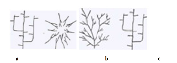
Types of Drainage Patterns
Dendritic Pattern: Tree-like branching pattern formed on uniform rocks.
Trellis Pattern: Formed where hard and soft rock layers alternate.
Radial Pattern: Streams flow outward from a central high point such as a volcano or dome.
Parallel Pattern: Streams flow in the same direction, following a steep, uniform slope.
Valley Development
Valley development is a geomorphological process in which running water gradually erodes land and forms valleys. Rainwater flowing over the land surface first moves as thin sheets, then forms small channels called rills. These rills combine to form gullies, which later join to form streams and rivers that cut deeper channels in the land.
Formation of Streams and Valleys
During heavy rainfall, surface water flows through gullies and gradually deepens them. With time, side gullies develop and grow into tributaries, collecting water from a large drainage area. The increased volume of water increases stream velocity and erosive power, which leads to further deepening of the valley.
Streams that flow only during rainy seasons are called intermittent streams. When a valley deepens enough to reach the groundwater table, the stream receives continuous water supply and becomes a permanent stream.

Graded Streams and Base Level
When a balance exists between erosion and deposition, the stream is called a graded stream. Such streams adjust their slope so that they can carry their load without excessive erosion or deposition.
The lowest level to which a river can erode its channel is called the base level of erosion. Usually, the sea level or the level of a lake acts as the base level for most rivers.
Valley Widening (Lateral Erosion)
In addition to deepening, valleys also widen due to lateral erosion. In some regions, deep valleys with steep walls are formed where vertical erosion dominates, such as in the Colorado River valley.
Valley widening occurs through several processes, including:
Creeping and slumping of valley sides
Rain wash
Activities of plants and animals
Glacial erosion
Undercutting by streams
Action of tributaries
Another important factor is meandering. When a river bends, the water flows faster along the outer bank, causing erosion and gradually widening the valley.
River Development (Cycle of Erosion)
River development refers to the gradual evolution of landscapes due to stream erosion. As rivers erode the land surface over time, the landscape passes through different stages collectively called the cycle of erosion.
1. Youthful Stage
The youthful stage begins after uplift of land, when rivers start eroding the surface. In this stage, stream gradients are steep and erosion is very rapid. Valleys are deep, narrow, and V-shaped, and the valley sides are steep.
Streams flow rapidly and often contain rapids and waterfalls. Tributaries are few, and the drainage system is not fully developed. A classic example of a youthful valley is the Grand Canyon formed by the Colorado River.
2. Mature Stage
In the mature stage, erosion continues and the landscape becomes highly dissected by numerous valleys and tributaries. The valleys become wider with gentler slopes, and the sharp features of the youthful stage gradually disappear.
Streams develop gentler gradients, and erosion becomes slower. Lakes and swamps are drained or filled, and waterfalls gradually disappear as the river approaches a graded condition.
3. Old Age Stage
In the old age stage, erosion reduces the land surface close to the base level. Valleys become very wide with gentle slopes, and the streams flow slowly with large meanders.
At this stage, rivers deposit more sediment than they erode. The landscape eventually becomes a nearly flat plain called a peneplain.
Monadnocks
Even in a peneplain, some isolated hills made of resistant rocks remain standing above the plain. These residual hills are called monadnocks, named after Mount Monadnock.
Types of Streams
Streams are classified into different types based on their origin, flow direction, and relationship with landforms and rock structures. The classification of streams helps in understanding the geological history and development of drainage systems.
1. Consequent Streams
Consequent streams are the first streams that develop on a newly uplifted land surface. Their direction of flow is mainly controlled by the original slope and natural irregularities of the land surface. These streams flow down the initial slope of the terrain and therefore directly follow the original topography.
As erosion continues, consequent streams may extend their length by headward erosion and widen their valleys. Tributaries may also develop as a result of the initial slope conditions. Consequent streams are commonly found in regions of massive or horizontally lying rocks and usually show a dendritic drainage pattern, which resembles the branches of a tree.
2. Subsequent Streams
Subsequent streams develop after the formation of consequent streams and are influenced mainly by the structure and resistance of rocks. These streams flow along zones of weak rocks or softer rock layers, where erosion occurs more easily.
Their course is not controlled by the original slope of the land, but rather by differences in rock hardness and structure. Subsequent streams often join the main consequent streams at nearly right angles, forming a trellis drainage pattern. This pattern commonly develops in areas with alternating hard and soft rock layers.
3. Obsequent Streams
Obsequent streams are tributaries of subsequent streams that flow in the opposite direction to the original consequent streams. These streams develop due to erosion in regions where the rock layers are tilted or inclined.
Obsequent streams are commonly found in areas with cuesta landforms, where erosion gradually wears down the land surface and forms new stream courses flowing opposite to the initial slope direction.
4. Antecedent Streams
Antecedent streams are rivers that existed before the uplift of mountains or other geological structures. When the land was uplifted due to folding or faulting, the river maintained its original course by continuously eroding its channel.
As a result, the river cuts deep valleys or gorges across the rising structures. The term "antecedent" means that the stream is older than the uplifted landform.
5. Superimposed Streams
A superimposed stream is one that develops on a surface of younger rock layers and later cuts down into older underlying rocks. Initially, the stream flows according to the surface topography of the overlying rocks.
As erosion removes the upper layers, the stream continues to maintain its original course even when it reaches different rock structures below. Therefore, the stream path is independent of the underlying geological structure.
River Erosion
River erosion is an important geomorphological process in which running water erodes, transports, and deposits rock materials. During the normal cycle of erosion, the development of a river system may be interrupted by various geological processes, which modify the landscape and sometimes start a new cycle of erosion.
Causes of Interruption in River Erosion
The normal erosion cycle of a river may be interrupted by several geological processes such as glaciation, volcanic activity, and diastrophism. These processes modify the land surface and influence the erosion and drainage pattern of rivers.
1. Glaciation
Glaciation interrupts river erosion when glaciers fill river valleys with ice or cover the drainage basin with snow. This cover protects the surface from weathering and stream erosion.
When glaciers melt and retreat, they deposit large amounts of glacial debris over the landscape. These deposits modify the existing topography and may create new youthful landforms, even in areas that had already reached advanced stages of erosion.
2. Volcanic Action
Volcanic eruptions may interrupt river erosion when lava flows into valleys and block or fill river channels. This obstruction temporarily stops the river's normal erosional activity.
After the lava cools and erosion resumes, the river may create a new drainage path or begin a new cycle of erosion in the affected region.
3. Diastrophism
Diastrophism refers to large-scale movements of the Earth's crust, such as uplift or subsidence. These movements change the level of land and influence the erosion cycle of rivers.
Subsidence (Downing)
Subsidence occurs when land sinks or sea level rises, bringing the land closer to the base level of erosion. As a result, rivers have less material to erode, and the landscape may reach the stage of old age more quickly.
When sea level rises along coastal areas, the lower parts of river valleys are flooded, forming bays and estuaries. This process is known as drowning of valleys, and tributaries may become separated and enter the sea individually.
Rejuvenation of Rivers
Rejuvenation occurs when uplift of land increases the gradient of rivers, giving them renewed energy for erosion. This commonly happens when land rises before the region reaches the final stage of erosion called peneplanation.
Due to increased slope, rivers begin to cut deeper valleys, gorges, or canyons into their old valley floors. As a result, the landscape once again shows youthful features, and the rivers are called rejuvenated streams.
Entrenched or Incised Meanders
If a river had meanders before rejuvenation, it continues to follow the same curved path even after uplift. However, due to increased erosion, the river cuts deeply into the valley floor, forming steep-sided valleys called entrenched or incised meanders.
A well-known example is the San Juan River, which shows classic entrenched meanders.
In India, similar features are seen in the Krishna River near Srisailam.
Stream Terraces
Stream terraces are step-like benches along the sides of river valleys. These terraces represent former valley floors that were abandoned due to renewed erosion.
When erosion increases suddenly, the river cuts a new deeper valley within the old valley floor, leaving the previous floodplain as terraces on either side of the valley.
River Erosion Cycle
River erosion occurs in three stages:
Youth Stage:
Steep slopes, deep V-shaped valleys, waterfalls, and rapids are common.
Mature Stage:
Valleys widen, meanders develop, and erosion becomes slower.
Old Stage:
The land becomes nearly flat forming a peneplain, with slow flowing rivers and broad flood plains.
River Capture (Stream Piracy)
River capture occurs when one stream erodes headward and diverts the flow of another stream into its own channel. This process changes the drainage pattern of the region.
Associated Landforms
Important landforms produced by river erosion include:
Canyons and Gorges: Deep, narrow valleys with steep sides.
River Terraces: Step-like benches along river valleys.
Mesas and Buttes: Flat-topped hills formed by erosion.
Ridges and Cuestas: Landforms produced by differential erosion of rock layers.